

After putting in some overtime hours at work, decided I’d take off to Anza Borrego and do a little over night trip for my birthday. Along the southern border of the park an old overland route makes it’s entry into the parks border and works it’s way north. While the Southern Emigrant Trail isn’t nearly as popular as the Mojave Road in today’s time, it may have been more widely used in the past.
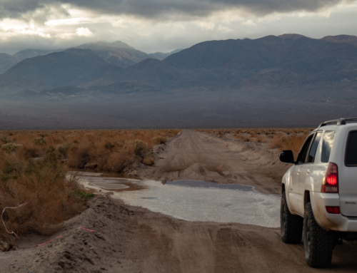
A relatively short drive put me in the small town of Ocotillo to top off on fuel, then tires on the dirt near Plaster City in a little under an hour and a half.
The Southern Emigrant Trail has a long and interesting history. In its heyday, it was the major overland route in and out of Southern California, and it played a part in every era of California history for more than a century. Its most famous era was the period from the start of the Mexican War, through the California Gold Rush, and on to the days of the Butterfield stage.
But unlike many other early overland trails, the Southern Emigrant Trail survived the coming of the railroad, and was still being used to cross the California desert well into the twentieth century. – Source Credit Branding Iron, Los Angeles Corral of The Westerners


The Colorado Desert is one of three that reach into California. To the north is the Mojave then the Great Basin that lays east of the Sierra’s.
Five million years ago tectonic forces ripped Baja California from mainland Mexico and created a large rift valley – the Gulf of California, flooding present day Imperial Valley and extending a shallow sea as far north as Indio, California.
At the same time, the Colorado River was busy carving a path through the Colorado Plateau, etching out the Grand Canyon and delivering loads of sediment toward its delta in the gulf. Three million years would pass before river sediments formed a large natural dam at the delta, holding back water from the gulf, and cutting the shallow sea in two. Isolated, the stranded sea to the north evaporated.

I picked up the overland route near Plaster City where the Southern Emigrant Trail and the Juan Bautista de Anza Expedition trail (pretty cool history in itself and also how California’s largest state park got it’s name) overlap for a short distance before going their separate ways. It’s worth mentioning that throughout the early years various paths led man to essentially the same destination, and they all have their spot in history. Different names were used throughout it’s progression and changes, but my trip will be based off it’s later years when it was used by settlers & 49’ers that were moving into California and as a route for the Butterfield Overland Mail service.


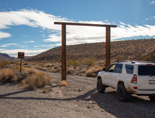
It’s a short distance before the two trails split. Emigrant trails heads west, while the Anza Expedition ventures north. Have to cross under the “overlander gatekeeper” before proceeding. This railroad which extends from Plaster City is the last operational industrial narrow gauge railroad in the United States, owned and ran by United States Gypsum Corporation – the largest distributor of wallboard in the US and the largest manufacturer of gypsum products in North America. Neat.


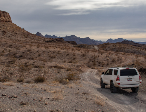
Continuing along the West Mesa, you enter a grey area of land ownership/boundaries – The Carrizo Impact Area. Used by the Navy as an air-to-ground bombing range during World War II and the Korean War, then turned over to the State Park in the late 1950’s.
Let’s touch a little bit on accessibility of places like this. I for one, am all about respecting signage and gates. While it’s a major bummer losing access in one form or another, sometimes it is what it is. But, if an area has illegible or unclear signs, how am I supposed to know what it’s indicating? Are these rules still being enforced or are they artifacts from a past time? Does it imply that it’s directly behind and everywhere in front of is fair game? Is it just that one trail?
I’d think, and this is just me, if this area was a hard closure and they were persistent of keeping people out they’d be on it with keeping it clear that this is a no-go zone. I’ve been in spots far more remote that are properly marked in some form, stating or showing that entry is forbidden, whether it be by motor vehicle or foot. From fences, gates, signs or more commonly a simple marker staked directly in the middle of the trail. In addition, there have been places where people have obviously bypassed these clear and unmistaken “barriers”, and I’ve always stuck to the rules being a respecting explorer by not proceeding.
That was far from the case here. What was to come was an absolute mess of land management.


Came across these bean bag looking deals that looked like they had water bottles strapped to the top of them. Given I knew where I was, I didn’t get close. Targets? Dummies? A secret drop for a drug cartel? Maybe they were filled with cash…
Keep in mind that at this point there were trail markers, signs of heavy OHV use and I even stumble across a memorial site. According to maps I utilized for my planning, the overland route was all BLM “public” land, except for one area up ahead and where it eventually enters the official Anza Borrego State Park.


The ’49ers have become a part of our American mythology, but the Gold Rush was nearly a year old before they began to arrive. The first outsiders to reach the new California gold fields came from Mexico in 1848, and they came across the Southern Emigrant Trail.
About a third of the sixty thousand or so ’49ers who came overland to California came by way of the Southern Emigrant Trail—perhaps as many as twenty thousand of them. Thousands more followed in their wake as the Gold Rush continued on into the 1850s. Yet the trail is hardly mentioned in most histories of the Gold Rush
Most of the ’49ers who traveled the Southern Emigrant Trail came from the South. About three thousand miners came by way of Texas in 1849, another three thousand left through Arkansas that spring and summer, and about twenty-five hundred more came via Missouri on the Santa Fe Trail (though some of them traveled south from Salt Lake City and followed the Old Spanish Trail into California across the Mojave). – Source Credit Branding Iron, Los Angeles Corral of The Westerners


Time to play the sign game. This is on the Emigrant Trail. First first set says Warning – The area behind sign – May be contaminated with exploded military ordnance. About all I can make out on it. I ventured a little further up and was greeted with a few more, these being a bit more pronounced and recent. Keep Out? Ok, you got it. No problem. You can see roads in the foreground and it’s clear this way is closed. I decided to back track a bit and take another trail that veered south of the Southern Emigrant Trail and joined up with another road that merged further up. Not a single sign. Nor did I spot another one until the Carrizo Stage Station.
It’s apparent that many disregard the legible signs and continue on. There’s also some rouge tracks here and there from those that are actively looking for the buried explosives. The only paths I used were well defined and have been around and well traveled for a long, long time. So it wasn’t as if I was trying to sneak my way around. Actually, it’s the only other way to continue on a established trail. Why the park service/BLM didn’t mark these very apparent and obvious roads is beyond me. What’s opened? What’s closed? What’s your thoughts?
Anyways, I decided to continue on. The road eventually drops off into the Carrizo Wash where it meets back up with the Southern Emigrant Trail.


Dropping into the wash the scenery starts to change and become a bit more dramatic. What a trip it must have been back in the day to see the world around you become increasingly more alien day after day.
Carrizo Creek, its wash and its tributary, Vallecito Creek, were the watercourses that carved the pathway from the Peninsular Ranges of Southern California through the Carrizo Badlands to the Colorado Desert. They provided a pathway and water for Native Americans travelers out into the desert and on to the Colorado River along the course of the distributary New or Alamo Rivers.
Subsequently, from 1828 it was similarly used by Mexican travelers on the route of the Sonora Road to Alta California, then by Americans on Cooke’s Wagon Road and its successor the Southern Emigrant Trail. It was the route taken into California by the San Antonio-San Diego Mail Line and Overland Mail Company. Both companies used the Carrizo Creek Station at the lower end if the creek in the badlands. – Source Credit Wikipedia


What seems like out of nowhere, water magically seeps from the riverbed forming a running creek. In the distance there’s an abundance of greenery – right where the old Carrizo Stage Station sits.


And then more signs. Sigh. Facing me – “No motorized vehicles”. AHHHHHHHHHH. Other side was Keep Out and warnings about the unexploded ordnance. I found myself in a pickle. Just above, in this very post I said that I respect signs and whatnot, yet I’m about to go against my own word. Yikes. It is what it is. I have nothing to hide and if anything, maybe this post will help persuade others from not following my lead on this one. Admittedly, I probably pushed the grey area. Looking back, I should have turned around. At this point I was between a rock and a hard place. Not supposed to be on either side. Ha. Go through and into “safety” of the state park, or drive back through a bombing range 😉 ? Roast away.


You want to talk about some history? The Southern Emigrant Trail has it. From the Indians, to explorers, the settlers and the mail route that ran through here – it’s wild. And there’s amazing documentation about it all, you could read first hand accounts and all the compiled research until your eyes fall out of your head. Click on any of the source credit links for more information, fascinating read if you’re into this sort of thing.
First built in 1855 as a U.S. military station, the adobe was strategically located adjacent to small, spring-fed Carrizo Creek, the region’s first reliable water source west of the Colorado River. Shortly thereafter, the site served as one of many swing stations that stabled four to five fresh horses and mules for use by incoming stagecoaches. During its first year of operation, the Carrizo stage stop serviced the San Antonio and San Diego Mail line from July 1857 to August 1858.
The Butterfield Overland Mail Company ran the line from September 1858 to June 1861 (Van Wormer et al. 2012:40). In addition to mail, the coaches also transported passengers. Those who stopped at the station long enough to eat, and sometimes overnight, likely helped to generate the animal bone food scraps recovered there.
The Butterfield Company employed section agents responsible for provisioning stage stops with food and other supplies. The Carrizo station was in Section 8, which ran from Yuma, Arizona to Los Angeles. Agent Warren G. Hall managed this section and arranged for delivery of all livestock and general foodstuffs to the Carrizo station.
Historical references indicate that from the 1850s to the 1870s,sheep and cattle were driven by the hundreds and thousands in both directions along the Carrizo coach (Van Wormer, personal communication 2013). Mail-line agents likely tapped into this convenient supply of meat on the hoof. – Source Credit Food Consumption At The Carrizo Creed Overland Stage Stop


I spent a bit of time here, breaking the law, breaking the law. Parked at the top of the hill and put away the phone, camera and any sort of modern convenience. Not a sound other than the slight breeze working it’s way through the vegetation. How many people have been through here? What was the struggle like to get to this point? Where were they going? Also, have you ever really thought or know about how your family heritage got to where it is? Have some of our ancestors passed through this very area seeking a new life with the dream of prosperity?
Figure, the views from here haven’t changed much. This is what they would have seen. The difference between then and now is that in present day, we can look up on a detailed map or satellite imagery and see exactly where we are in relation to things down to fine detail. Then, they had a vague paper map? No real sense of what was where or what it would look like. The only real information of what laid ahead was hearsay.
I nerd out on this kind of stuff.
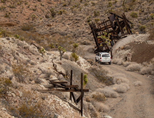
On the other side of the hill is another structure that’s being preserved to some extent. Not much remain other than old material that has crumbled to the ground, some stone work and a tractor that’s from the early 1900’s.


Tried to find the old grave marker of the Frank Fox but came up empty handed. It was getting later in the day and I was looking forward to finding camp & relaxing. Continued down the Southern Emigrant Trail, then turned up Vellecito Creek to find a solid spot tucked amongst the mud hills.


Found a solid spot north of the Hollywood-Vine campsite. Tucked in a little canyon it eliminated the fast moving air that decided to move in towards the end of the day. Took a short hike away from camp to overlook the surrounding area and sort of reflect on the day.
The first thing that came to mind was my frustration with signage. What a mess. I’m a well versed explorer, and have always been respecting when it comes to boundaries. This one really threw me for a loop. I’m not going to go over what I already said, but rather express what I feel like should happen.
Both the BLM and Anza Borrego State Park need to communicate, decide and enforce, one way or the other, the accessibility of the area. If they want it closed, put up more signs, gates, fences, etc. Eliminate or guide access. Because how it stands now it’s somewhat unclear depending on the route you take.
But that’s not what I think should happen. State parks and BLM are backed by the public’s tax dollar. You and I pay to fund these places. This area is also a major point of history – for the United States, California, and the families that now inhabit the west because of it’s creation. How about they spend some money/resources on preserving the Southern Emigrant Trail by creating an accessible gateway through such a incredibly rich piece of history.
Sweep the Carrizo Impact Area of any potential dangers along the main road, put up informational boards for those passing through so they/we can learn and enjoy what happened here while also letting the neighboring communities prosper from the additional tourism it would create. Why can the government litter and have no recourse on it’s actions but then point fingers at us for doing so much less? They’re supposed to work for us, not the other way around…
Frustrating at times. Rant over.


Like usual, the desert delivered on it’s last bit of sun. Unfortunately astrophotography was hampered by cloud clover.


Up early once again. Sometimes not by choice. At my work, we do a 9/80 schedule and we have a bit of flexibility of when we start. I like going in early, like I’m putting my hands on hardware at 4:00am early. Plus side to that is I’m off at 1:00pm. Works out great for me as I like having the remainder of the day to do whatever. The one downside is I’m programmed to wake up around 3ish. That’s been the case with my desert trips lately. Needless to say – I was up when it was still dark. Haha.
Thankfully I was able to fall back asleep for a little more rest before hitting the trail. Made my back to the overland trail for a short distance to the S2, aka the Great Southern Overland Stage Route Of 1849.


The Great Southern Overland Stage Route of 1849 vaguely follows the original. For nearly it’s entire length it lays just to the east. There were a few spots where I was hoping I could rejoin but unfortunately it’s blocked off.
County Highway S-2 is a desert road in south-central California with a fascinating history. Beginning at California Highway 79 near Warner Springs, the road leads south through the Anza-Borrego Desert in the Anza-Borrego Desert State Park. Known as the San Felipe Road, it is also known as Sweeny Pass, Imperial Highway and Great Overland Stage Route of 1849. The winding S-2 passes through Box Canyon and leads to the community of Ocotillo at Highway 8.
Alongside the roadway the soft desert sand, rocks, ruts, and cacti provide a glimpse into the past and the difficulties that plagued wagon wheels and horses hooves. Highway S-2 dates back to the late 1700s when, as a dusty trail, the Spanish used it. In 1826 it was Mexican mail route.
Famous people also used the trail, including Kit Carson and General Stephen Kearny, who led the Army of the West to war with Mexico. Mark Twain also rode the trail in a mail coach with his brother Orion, and wrote about it in his book Roughing It (1872). In 1861, his brother had been elected Secretary of the Nevada Territory and they left St. Joseph, Missouri, for the trip west. Passengers were allowed only 25 pounds of luggage with the coach carrying 2,700 pounds of mail. Travel by stagecoach, with the exchange for fresh horses at various stops along the way, provided a fairly quick journey for its day. – Source Credit Federal Highway Administration


First stop was the Vallecito Stage Station County Park. A tremendous amount of history surrounds this site and the nearby area, and you can even camp in basically the same place as so many did in the part. Due to covid, they have the station closed up but they did leave out the informational boards for visitors to read.
From the Native Americans who lived here for thousands of years, to the Spanish conquistadors, and explorers and soldiers such as Kit Carson and General Stephen Kearny, as well as emigrants in the early part of this century who still traveled by wagon, Vallecito has always been a green refuge in an often harsh land. Countless generations of Native Americans camped here before the arrival of the new Americans in the 19th Century, and these Newcomers left an indelible impression.
The Vallecito Stage Station is a testament to one of the most dynamic decades of this area’s history. First used as an army supply depot, then as a rest stop on the “Jackass Mail” route between San Antonio and San Diego, the building was busiest during the lifetime of the Butterfield Overland Stage (1858-1861). The stage line carried mail and passengers over 2,800 miles separating Tipton, Missouri and San Francisco in 25 days.
It was said to be the longest stage ride in the world.
Stage stations scattered along the route offered the weary passengers a brief meal and rest as the horses were changed. Then it was on to the next stop on the 24-hour-a-day journey. Vallecito was a favorite station since it was the first place with greenery that travelers saw after crossing the hostile mail route in the southern desert.
In 1934 the County purchased the building, which had been rebuilt using original materials. – Source Credit sdparks.org


There was an incredible amount of stuff to read and pictures of people that used to call this place home. Far too much to attempt to post. There wasn’t a single soul there other than the camp host which made the experience that much better.
A bit further up there’s a couple neat vantage points around Campbell Grade. Just below there’s access to a little more of the trail, and about halfway up Campbell Grade you can park on the pull out and see the original trail along the desert floor, as well as how that made it up the canyon. Bonus feature, Google Maps provides a neat prospective.


Speaking of Google Maps, you can actually see much of the original trail through the epic satellite imagery. Super cool to see.
A bit further up is one of the greater obstacles the travelers encountered – Box Canyon.
The old way variously known as Sonora, Colorado River or Southern Emigrant Trail and later as Butterfield Overland Mail Route traversed Box Canyon just east of here. January 19, 1847, the Mormon Battalion, under command of Lt-Col. Philip St. G. Cooke, using hand tools hewed a passage through the rocky walls of the narrow gorge for their wagons and opened the first road into Southern California.


Now into Blair Valley, you can rejoin the trail for a short distance as it works it’s way to Foot and Walker pass. The name is quite fitting.
Getting to and around Blair Valley via County Highway S-2 and two-wheel-drive-passable dirt roads is fairly easy these days. Not so in the stagecoach era when the Butterfield Overland Mail wagons struggled across Blair Valley and over the high desert passes. At the northern edge of the valley was a rocky incline known as Foot and Walker Pass; it was so steep that stage passengers were often forced to disembark and walk–even help push the stage–over the pass. Atop the pass is a monument commemorating the pioneers who came this way and an excellent vista of Blair Valley.
Before settlers came this way, the native Kumeyaay camped in Blair Valley. They left behind morteros (grinding rocks) and pictographs (rock art), which today can be reached via short hikes. – Source Credit Los Angeles Times


From here, I explored a bit of the Blair Valley area but it was so packed full of people I decided to start the journey home.


Continued north on the S2 to the intersection of Hwy 79. I’ve driven this road countless times on my way to the desert and I’ve always noticed the old house and structures right along the road, but never knew the history until now. Really wish I wasn’t in a hurry to get home as I feel I shorted myself on learning more about this historic place. I’ll be sure to stop by on my next journey though.
The Warner-Carrillo Ranch House, Built in 1857 by Vincenta Carrillo, a prominent early California woman rancher, the adobe known as the Ranch House at Warner’s served as the Butterfield Stage Stop from 1858
until the beginning of the Civil War in 1861. As California’s first regular overland transcontinental stage connection with St. Louis, this pioneering stage route ran along the Missouri Trail.The trail was the most southerly and only all-weather route to California. Built directly beside the emigrant trail, it figured prominently in the settlers’ diaries as their first glimpse of the promised land, the first well watered valley to be encountered after crossing the great southwestern deserts. The historic setting has changed very little from the time of the great western migration and presents a rare opportunity to experience the past.
The adobe maintains a high degree of integrity including a great deal of its historic fabric including the original fireplace mantle, much woodwork and vigas (ceiling beams).
The ranch house plays a leading role in the history of the American West. It represents Mexican and American culture contact during the Mexican Republic; the Frontier period of the westward migration; and the Gold Rush and the cattle ranching industry from 19th century California to 20th century to today.
Its importance as the southern emigrant overland trail and Butterfield Stage Station cannot be overstated and it is for this significance that it was designated as a National Historic Landmark in 1962.
It still sits in the midst of a huge expanse of open space, a setting virtually unchanged from the mid 19th century. – Source Credit sohosandiego.org


Super fun and history rich trip. There’s still more to check out and am already in the works of getting those areas explored.
Until next time!
Another great trip! Enjoyed reading all the history.